Oracle 1z0-595 Exam Practice Questions (P. 2)
- Full Access (75 questions)
- One Year of Premium Access
- Access to one million comments
- Seamless ChatGPT Integration
- Ability to download PDF files
- Anki Flashcard files for revision
- No Captcha & No AdSense
- Advanced Exam Configuration
Question #7
Which command will combine two simple overlapping polygons (geom1 and geom2) into a single geometry that excludes the overlapped region?
- ASDO_GEOM.SDO_EXCLUDE(geom1, geom2, .05)
- BSDO_GEOM.SDO_INTERSECTION(geom1, geom2, .05)
- CSDO_GEOM.SDO_UNION(geom1, geom2, .05)
- DSDO_GEOM.SDO_XOR(geom1, geom2, .05)
- ESDO_GEOM.SDO_AGGR_UNION(geom1, geom2, .05)
- FSDO_GEOM.SDO_DIFFERENCE(geom1, geom2, .05)
Correct Answer:
D
returns a geometry object that is the topological symmetric difference (XOR operation) of two geometry objects.
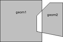
SDO_GEOM.SDO_XOR -
In Figure below, the shaded area represents the polygon returned when SDO_XOR is used with a square (geom1) and another polygon (geom2).
References:
https://docs.oracle.com/cd/B28359_01/appdev.111/b28400/sdo_objgeom.htm
D
returns a geometry object that is the topological symmetric difference (XOR operation) of two geometry objects.
SDO_GEOM.SDO_XOR -
In Figure below, the shaded area represents the polygon returned when SDO_XOR is used with a square (geom1) and another polygon (geom2).
References:
https://docs.oracle.com/cd/B28359_01/appdev.111/b28400/sdo_objgeom.htm
All Pages